


Gallery-quality prints · Independent artists · Décor to adore

” by ArtHistory")

from $ 15
” by ArtHistory")

from $ 15
” by ArtHistory")

from $ 15
” by ArtHistory")

from $ 15
” by ArtHistory")

from $ 15
” by ArtHistory")

from $ 15
” by ArtHistory")

from $ 15


from $ 15
” by ArtHistory")
from $ 15
” by ArtHistory")

from $ 15
” by ArtHistory")

from $ 15


from $ 15
” by ArtHistory")

from $ 15
” by ArtHistory")

from $ 15
” by ArtHistory")

from $ 15


from $ 15
” by Alleycatshirts")

from $ 11
” by ArtHistory")

from $ 15
” by ArtHistory")

from $ 15
” by ArtHistory")

from $ 15
” by ArtHistory")

from $ 15
” by ArtHistory")

from $ 15
, New York (1873)” by ArtHistory")

from $ 15
” by Alleycatshirts")

from $ 11
” by ArtHistory")

from $ 15


from $ 15
” by ArtHistory")

from $ 15
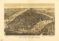
, New York (1890)” by ArtHistory")

from $ 15
” by Alleycatshirts")

from $ 11


from $ 15